Feature
Rivers and floods
River hydraulics and flood simulation.
Use this add-on:
Overview
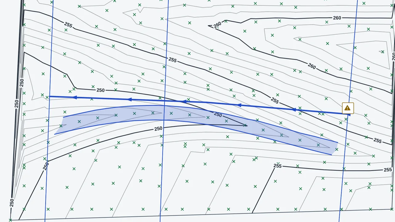
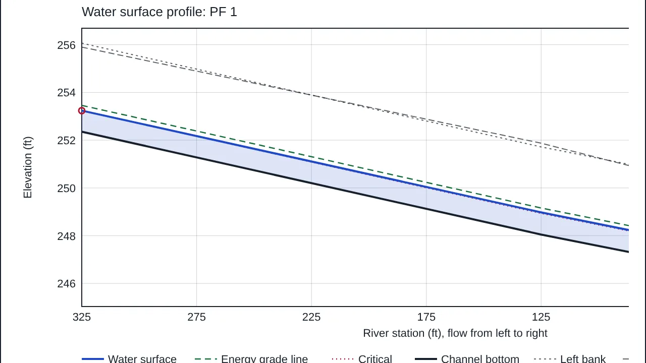
Rivers and floods models a river from the ground surface in CivilCraft and computes steady one-dimensional water surface profiles by the standard step method. For each flow you give, it reports the water level, energy, velocity and Froude number at every cross section, and shows the flood extent on the plan. Culverts and bridges can be placed between sections, and a flood hydrograph can be routed down the river as unsteady flow. Every result needs an engineer's review. The help marks the river feature as a lab feature while it is checked.
Who it’s for
- Hydraulic and flood engineers: water levels along a river for a given flow.
- Floodplain and river planners: the flood extent on the plan, with levees and ineffective flow areas taken into account.
- Designers checking a culvert or a bridge opening: the headwater, the control that governs, and whether the opening chokes.
- Engineers routing a flood: the peak water level and flow at each section from an inflow hydrograph.
What you can do
- Draw a river from the existing ground (points, breaklines or a TIN) with Surface, More, River, clicking along the centerline from upstream to downstream.
- Set the flow regime (subcritical, supercritical or mixed), the flow profiles and the boundary conditions in the river's Properties.
- Cut the sections from the ground with the spacing and bank guesses you choose, and edit the sections table (bank offsets, Manning n, reach lengths, contraction and expansion coefficients).
- Edit a section with Edit: banks, levees with their crest, and ineffective flow areas.
- Compute the water surface profiles and read the plot, the table of each section, and the warnings. Save the table as CSV, the report as plain text, or the plot as SVG.
- Show the flood extent on the plan for a chosen profile (Show the flood extent).
- Add a culvert (box or round) or a bridge between two sections, and read the structure table in Results.
- Route a hydrograph (hours and flows, one pair per line) with Unsteady flow.
Methods and standards
Steady flow: the standard step method, with the energy balance between neighbouring sections (water surface plus velocity head, equal to the water surface plus velocity head upstream plus the friction loss over the reach plus a contraction or expansion term). Conveyance by subdivision, K = sum of (1/n) times A times R to the two-thirds, with 1.486/n in US units; friction slope by average conveyance. Critical depth is the least specific energy, and each water level is solved on a bracket. Culverts: weir flow while the entrance is free and orifice flow once drowned, blended; outlet control by the energy balance. Bridges: the opening below the bridge, with the piers as areas that carry no flow. Unsteady flow: the full one-dimensional equations solved by an implicit four-point scheme, weighted 0.6 in time.
Data and sources
The ground is the surface you build from points, breaklines or a TIN. Manning n values, reach lengths, bank positions and boundary conditions are typed by you; the starting values are first guesses. The culvert and bridge coefficients (discharge, entrance loss, weir) are round-number defaults, not the fitted charts of design manuals.
Verification
The Node tests in bin/test-civilcraft-river.mjs and bin/test-civilcraft-river3.mjs. Run on 2026-10-29: river 122 passed, 0 failed; river3 54 passed, 0 failed. They check Manning normal depth against a bisection solution, critical depth in a rectangular channel, the backwater curve of Chow (1959), Examples 10-1 and 10-2, and, in round 3, hand-worked culvert, bridge, junction and unsteady cases. Not yet checked against a measured flood or a reference model of a real river.
Limits
A one-dimensional model: it is only as good as its sections, roughness values, reach lengths and boundaries. It does not know about bridges, culverts or flow leaving the river unless you add them. A culvert's headwater near its limit is an estimate. Not built yet: weirs and gates as their own structures; a panel to join two rivers on the plan (the junction model exists); structures inside an unsteady run; supercritical unsteady flow. A mixed-regime run flags a hydraulic jump between sections but does not place it. Not a substitute for an engineer's review.
Files and formats
Saved in the CivilCraft project file. The river's lines go to the plan, the PDF and the DWG on their own layers: C-WATR-CNTR for the centerline, C-WATR-SCTN for each cut line with its river station, and C-WATR-FLOD for the waterline of the flood extent. Outputs: the profile table as CSV, the report as plain text, and the plot as SVG. Each output carries the review line.
Get started
- Build the existing ground surface first, from points, breaklines or a TIN.
- Open Surface, More, and choose River. Click along the centerline from upstream to downstream, then press Enter.
- Select the river, set its flow profiles and boundary in Properties, then click Water surface profiles.
Languages
No languages are listed for this add-on yet. Its maker may add some.
Works in
| Edition | Works | Note |
|---|---|---|
| Browser (/use) (yours) | Added on demand | Fetched the first time you use it, then kept for offline use. |
| Studio from getcadcraft.com | Added on demand | Fetched the first time you use it, then kept for offline use. |
| Microsoft Store | Added on demand | Fetched the first time you use it, then kept for offline use. |
| Google Play | Added on demand | Fetched the first time you use it, then kept for offline use. |
| iPad and iPhone (App Store) | Included; switch it on | Part of the reviewed app; your list switches it on. |
| Custom build | Added on demand | Fetched the first time you use it, then kept for offline use. |
Comes with
Nothing else.
Needed by: Civil and site engineering, Coastal and ocean engineering, Dam and hydropower engineering, Water resources and hydrology.
Versions
| Version | Channel | Date | What changed |
|---|---|---|---|
| 1.0.0 | stable | October 28, 2026 | First version in the Library. |
Licence and maker
CadCraft (CadCraft, first-party). Licence: Apache-2.0. Dependencies carry their own licences, listed on their pages.